Saturday, June 21, 2014

Rainier's Liberty Ridge 2014 Climb

Rainier's Liberty Ridge route has everything that makes mountaineering so alluring to me: long approach, remoteness and isolation, steep snow and ice climbing, rock scrambling, high elevation, multi-day backpacking, beautiful views, and manageable objective hazards. This route has been on top of my list for several years now, and this year - the stars aligned, and my wife Jola, good friend Natan and I completed the climb in the middle of June. There was perfect weather right from the start to the climb all the way down to Camp Sherman, where we encountered partial white-out on the last day. The climb started on Sunday, June 8th with summit on Wednesday, June 11th, and we were back at the car on Friday, June 13th.

Pre-trip planning:

The planning started several months before the trip - extensive research was done on the approach, route, variations, gear, and logistics.

After carefully weighing everything I considered bringing on the climb, it was clear that having a pack weighing anywhere under 40 lbs would be extremely difficult. When weighing the final pack, I decided to take into consideration only what will actually be in the pack at the time of climbing the steepest parts - anything else on me I wouldn't count - such as rope, ice tools, crampons, ice screws, carabiners, etc. The total pack came out to be about 44 lbs (minus whatever food would be gone by that time). The total weight I would be carrying (including backpack and everything on me) would be around 55 lbs.

On Saturday I picked up my backpack and decided that it was too heavy. I began throwing things out of it, starting with the shovel (Natan had the other shovel, so we ended up going with 1 shovel). I removed about a total of 2-3 lbs of extra/backup items.

Sunday, June 8: White River trailhead to Lower Curtis Ridge, 6.4 miles, 3000' elevation gain, 11 hours

We got to the White River campground parking lot around 8:30am. First couple of miles were almost completely snow-free. At some point we came up to a place where we initially thought a large stream crossing was inevitable, but it turned out that we had to make a sharp uphill-right instead. The path was now wanded with red NPS wands, and we followed it for another couple of miles.


After a while we hit the snow field, put on our glacial goggles, to avoid going blind, and followed it up towards the pass.


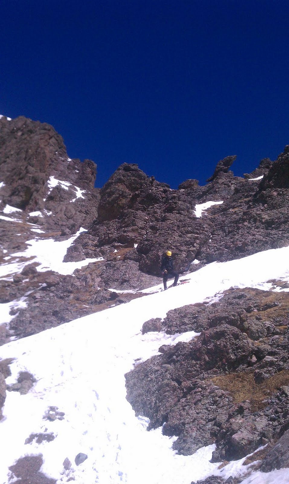
On the way up we saw a few skiers going down from Camp Sherman area on (what at the time seemed to be) very steep snow. The way up towards the pass was steep, and once we got to the top, it was windy, but there were spots that protected from the wind - and that is where we dropped our packs and had lunch.


Going down the pass started very rocky, and then got us to the snow again, after 30-40 feet of rock down-scrambling. As we got down to Winthrop Glacier, we roped up and started the traverse over to Curtis Ridge.


At some point Natan, who was 2nd in our party of 3, had one of his feet punch through a crevasse, and sunk up to thigh level. It was getting late in the day and the snow was getting slushy. We had amazing views of Liberty Ridge, as the whole day was very clear, with only some patches of clouds going by.


We've set up camp on a flat spot near 7500', cooked water and dinners and went to sleep.


Monday, June 9: Lower Curtis Ridge to Thumb Rock, 3200' elevation gain, 10 hours

We started to move around 9 am, and had to go down a couple of hundred feet, since otherwise we would have to do a sketchy rappel. In hind sight, I really wish we rappelled instead, as it would have saved us several hours of climbing down then going back up. We got down to the rocks and then over to the Carbon glacier, where we roped up again and started heading towards Liberty Ridge.


At one point I fell through waste-deep into the hole on the edge of a 20-foot-wide crevasse. My backpack stopped me, and I climbed out. Right there and then pulled out my avalanche probe and used it extensively. We had to zigzag a bit to avoid the crevasses on the way - we passed quite a few of them, jumping or walking across some of the smaller ones.


We gained the ridge on the west side, and kept going up until we got to a point where it seemed that the way ahead wasn't passable, and the only way to go was up was through a really sketchy rock scramble that started off with a 10-foot easy class 5 rock climb. I got up and went over about 100 ft, screaming "ROCK" every couple of minutes to the team, to notify them of me dropping large rocks. I found a place for a more or less decent sitting belay, and brought them up one at a time.


We kept moving up and saw a couple of rock formations that we mistook for Thumb Rock. We were climbing on the left side of the ridge, on the snow slope, and then got over to the right side.


Finally we found the place, which was very obvious, especially due to the fact that there was a tent platform dug out there. We extended the platform to fit our tent, boiled water for dinner and for next day, and went to sleep.


Tuesday, June 10: Up from Thumb Rock to 13,300 ft

We roped up and started the climb on the left side of Thumb Rock, which was steep snow, and partially exposed rock. At times we were moving on steep snow, and other times it would turn into solid ice.

At one point a grapefruit-sized rock flew by on my left, appearing out of nowhere, and missing my head by about 2 feet. I barely had time to put my head down.

I had a total of 6 screws with me: 1x22, 2x19, and 3x16 - but I eventually dropped one of the 16cm screws.  On steep ice, we started belayed climbing, where I would climb up and set up a belay station consisting of 2 screws, then bring up the team one at a time, go up putting in 1 screw in the middle, wherever necessary, then set up the next belay station.

We did some zigzagging, trying to find more of snow-climbing areas rather than pure ice, since we were taking too much time on the ice parts. After looking at the map again, it became obvious to me that we should have kept more to the right, by the Black Pyramid, instead of keeping to the center and traversing left. This would have saved us a lot of time, and we most probably would have avoided the sketchy bivvy that we had to resort to at the end of the day.

I believe we've ended up taking this route up past Thumb Rock, with red route being the route from Thumb Rock to the bivvy at 13,300, then orange route to the summit.


By around 7pm we decided that we need to find a place to bivvy, since we were taking too long, and had little chance of getting to the crater before dark. We ended up on the top left part of the snow/ice climb that was on the left side, past Black Pyramid, and got to a place that ended with something that looked like a W-shaped hole few hundred feet up at the top. I went up about 200 ft to see if this was the right way, but realized that I didn't want to bring up the team since we weren't sure it was the right way, and I didn't feel comfortable climbing on steep ice w/o belay, at 13,500 feet elevation.

We looked for a flat (or as flat as it gets over there) spot to spend the night. There were a couple of potential candidates, including a small ledge, which seemed to be too small for us. There was another spot that looked promising but steep and small, so we'd have to dig out a platform, and we weren't sure it'd be big enough. We kept going for another few feet on the tiny ledge that was hugging the rock wall, and behind the corner we found a steep slope which we decided to use to dig a platform. The slope consisted of many layers of snow of different density. Some were very hard, and some soft. I was worried about avalanche danger, but saw several large rocks protruding in the middle of the snow slope under us, that made me think that we were more or less safe in that regard. The rock wall we were next to looked fragile, but there was no evidence of any recent rockfall.


Initially we were thinking of digging out a platform big enough to hold the tent, but after over 5 hours of digging decided to settle for a small bivvy that was just big enough for 3 of us, covered with the tent tarp, anchored at the top with dead man anchors. On the bottom we've set up a rope between two snow anchors, to prevent us from inadvertently sliding down in our sleep. We were all worried about that part, especially me, with my sleep-walking history.

At some point in the evening we saw a 20-story-building-sized serac collapse and trigger a huge avalanche.

Wednesday, June 11: 13,300 bivvy to summit, 1000 ft elevation gain

The strong sun woke us up - we went to sleep wearing every piece of clothing we had on us, and by the morning we became incredibly hot. Snow was becoming slushy outside, and we started packing up.


We packed one at a time, due to the limited space on the platform we dug out the night before.


After having breakfast, boiling water, and finishing packing, we roped up and started to carefully move back to the spot where I went up the night before.


Initially we started climbing towards the "W" shape on the top, but then mid-way saw a set of foot prints leading right, towards the snow field. The traverse was going straight under an ice fall, and we moved quickly to the safety of the snow field to the right.


On the top of the snow field the wind picked up considerably, and we eventually topped out past the Bergschrund via steep snow going up right, leading towards Liberty Cap.

The time was close to sunset, and we had beautiful view all around us. We passed Liberty Cap and kept going downhill, towards the fork that leads down Winthrop Glacier. Past the fork, the climb continued towards the crater and the summit. By the time we got to the summit the sun was already set, but it was very light out, due to full moon.

After summitting and hanging around on the summit for a minute or two, we continued on down into the bowl and found a nice flat spot in the North-East part of the crater. We've set up the tent there, boiled water for the night, and went to sleep.


Thursday, June 12: Summit Crater to Camp Sherman, 5000 ft elevation loss

We didn't get much sleep as it was windy, even though the tent was somewhat sheltered by the walls of the crater. Winds outside of the crater must have been insanely strong. It also seemed that it snowed a little at night, although it could have been just snow moved around by the strong winds.

We left some gear outside, such as crampons, ice tools, snow pickets, and the rope. I were worried in the morning that everything will be covered by snow and we'd have trouble finding everything. It turned out to be fine, and most of the gear was visible in the morning.

I got of the tent first, and started looking for the way down. I saw a wanded trail, that I believe was Disappointment Cleaver. I went up to the side of the crater and decided to come down, since the wind was knocking me off my feet, and I wasn't wearing crampons.

We cooked in the vestibule of the tent, packed up, and started going down into the craters east side. We didn't see any good way down, so we went up the north side of the crater and headed down towards east. We eventually found a set of foot prints, confirmed with GPS, and headed towards Camp Sherman.


At some point we were able to see it on and off between the clouds on the bottom. Several bright tents were clearly visible. My right crampon didn't seem to be working very well for me, and it popped off 3 times. There were a few nearly flat spots on the way down where we rested. We saw the ranger cabin, which was a really cool looking stone cabin on the side of the cliff.


The way down was becoming less and less steep. We were going down unroped, and roped up only for the last thousand vertical feet or so, as we started seeing crevasses. At some point the snow field turned into deep slushy snow, which caused a lot of suffering, falling, and cursing due to post holing.

We got to the camp where we were greeted to a couple of climbers and their guide. They offered us some sports drink from their nalgene, some chocolate treats and hard candy, which we graciously accepted. They also told us that the climbing Ranger was in, and we went to see him, to tell him that we were delayed for a day. Jeremy (the ranger) got on the radio with the base and got our permit extended by a day. He also said it won't be a problem for us to stay overnight, since we didn't want to post hole any further.


We looked around for an open site and chose the largest one. We still had to extend it a couple of feet, since our tent was bigger than the platform. The platform was about 4 ft deep in snow, to shelter from the wind.

We set up the tent and cooked water, then went to sleep very early, around 8:30pm.

Friday, June 13: Camp Sherman to White River Trailhead, 5000 ft elevation loss

We slept very well, and woke up around 7am. During the night it snowed, and the tent was covered with about 2 ft of blown snow on each side. It was windy, and a lot of snow blown in under the vestibule, covering all our stuff there.


We cooked in the vestibule, cleared snow around the tent, packed everything up, roped up by the ranger cabin, and started heading down.

The way down included a few hundred feet climb up on a steep slope, followed by the climb down on the other side of the slope that we took going up St Elmos Pass.


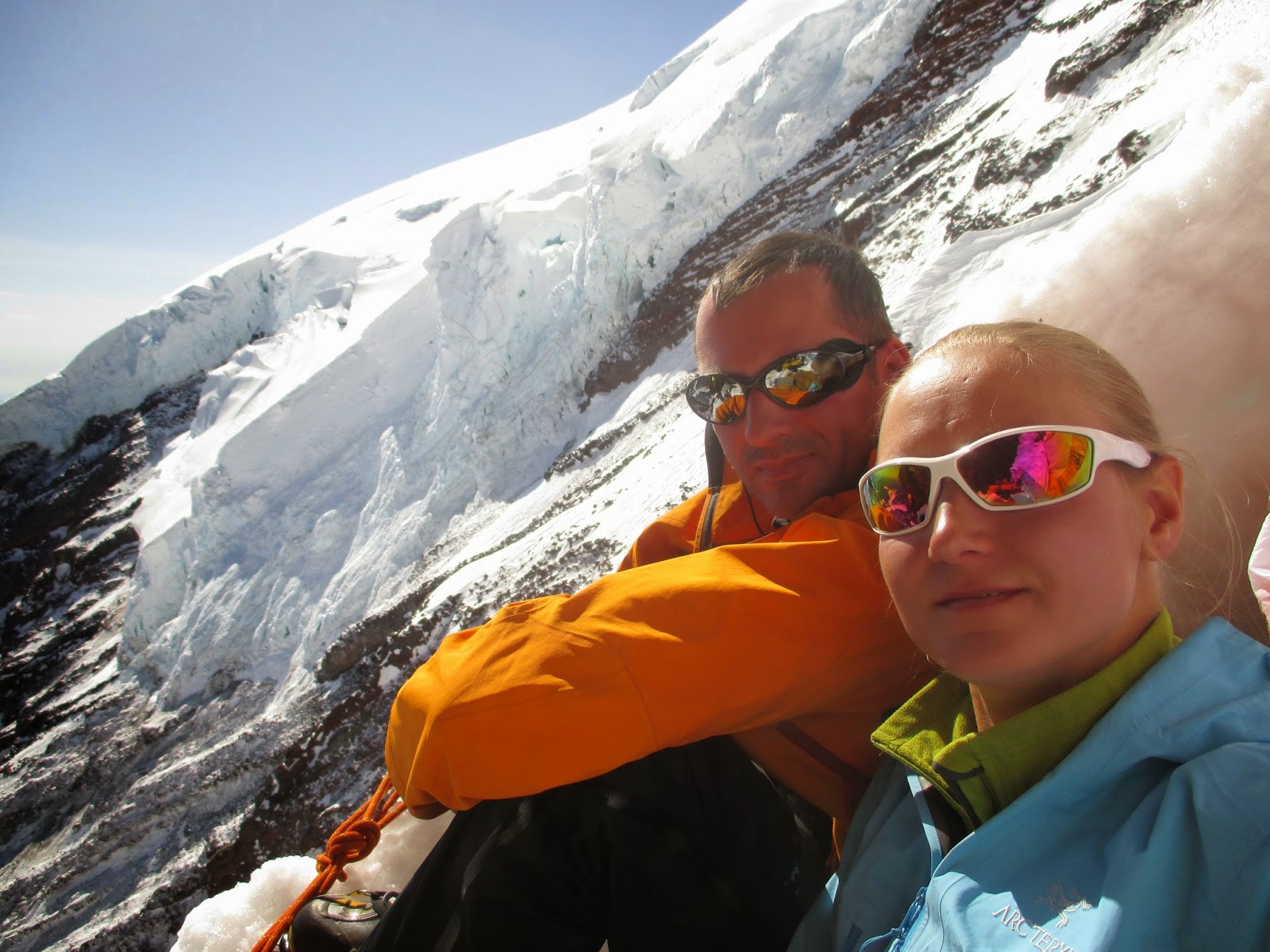
We butt-slided down part of the way, a good 1000 ft of somewhat gentle slope, then walked the rest of the snow field, when the angle of slope became too gentle to glissade. On the way down we met a couple of parties going up, that looked very jealous of our butt glissading. Another party of snowshoers passed us on the way down, and was kind enough to take a picture of all 3 of us:


At some point the trail changed into snow-less hike, we layered down, and finally found ourselves back at the car.


Lessons Learned:
  • Make it a point to go light, then go lighter. I would have trouble shaving off weight, but at least we could have taken a lighter tent, instead of 11.5 lb Trango 3. I also had 2 lbs of extra clothing I ended up not using, and 2 lbs is a LOT of dead weight to be carried up Liberty Ridge.
  • Take smaller tent. Smaller tent would also permit smaller tent platforms, in case those are needed to be dug. You won't be able to sleep much anyway, so comfort is not that important.
  • Take more photos. Although at some point we entered into survival mode and photos became secondary. My camera phone also died mid-way (I sat on it)
  • Learn route better. I believe we could have made it much easier on ourselves by following the snow patches to the right side past Black Pyramid, rather than zigzagging closer to the center and then going left.
  • Put a lot of sunblock, then put some more, and keep putting it on until your face is all white in it. Keep reapplying every hour. Use a lot of chop stick on your lips with high SPF.
Route Map:


Here's the link to my gear list.

Sunday, June 12, 2011

2011/06/11 - Hudson Valley fun

This weekend's plan was to do a few laps of Breakneck. I packed all my ultralight hiking and basic camping gear on Friday night, and went to bed around 11-12. Wake up call rang at 5am, I got up, had breakfast, loaded the car, and headed up North to join Dorothy for the Breakneck laps. I was running late for the 7 am gathering, so I called up Dorothy and told her not to wait for me. They started around 8:00 am.


I arrived at Breakneck Point about 8:20 am, parked right off the start of Breakneck and started the scramble after spending a few minutes chatting to a guy who was taking his 2 little sons for a hike there.

Dorothy's group consisted of Dorothy herself, and two younger guys, one of whom was shooting a hiking documentary video for his school project. I caught up to them at the flag pole (the first vista point). Sticking with the group all the way to the top (or in our case the 3rd vista point), I ran down, and did another lap. One of the guys decided to take it easy and was relaxing by some rocks, I passed him on the way down while doing my 2nd lap. As I was going to go for the 3rd lap, I got in touch with Dorothy and decided to join her and the film student for some breakfast in Cold Spring. It took me a little while to find the place. I had a couple of eggs over easy with home fries, bacon, and sausage. We talked about hiking, mountaineering, and climbing. Stav, who was shooting the video, was 20 years old, and seemed very eager about all the outdoor activities. I convinced the two to join me for a "baby dike" scramble. After finishing with breakfast, we jumped into our cars, and took a ride to the Little Stony Point parking lot.

It took about 20 minutes to walk up to the start of the scramble, and we got up to the rocks, avoiding Poison Ivy, and climbed up.


Another group of about 5-6 people was watching our progress, and asked whether the scramble was a difficult one. I asked whether any of them rock climbed, to which they said no. To play safe I told them that the scramble is not easy - which I think was the right call, since there are a couple of places on the way up that I would consider somewhat "iffy", especially for someone that doesn't have much hiking and climbing experience. The party decided against climbing up, which was a good call on their part.


On the top of the climb, we took a few pictures, and walked down, following the top of the cliff. We got down to the cars and parted ways.

At this point I thought about my options on where to go next, and considering possibility of continuing to do Breakneck laps. This seemed to be a somewhat boring endeavor, and I decided to do the small Beacon loop (17 miles). I parked the car at the same place as in the morning and started to scramble up. It was 12:45pm and I set 6 hours as my round trip goal for the hike. Few hundred feet after the start I passed a couple of cops chatting with two other hikers. It looked like the cops were just taking a hike up, rather than responding to an emergency call. I kept going, and got past Beacon Casino only meeting a couple of small groups of people.

The weather was refreshingly cool, and not too humid - which was a blessing, considering that almost the entire previous week was close to 100F, with high humidity. Around the mid-point of the hike I saw a message from Brendan that he's in the Bear mountain area. I messaged back telling him that I was thinking of camping out and asking if he wanted to join in. He replied affirmatively and we agreed to check back around 6 pm, which was the time I told him I should be finishing up. I was making good progress, and I figured that there's a chance I can finish by 6 pm. I also put on my headphones, turned on the mp3 player, and picked up my pace. I find it that listening to hard rock, such as Breaking Benjamin or Disturbed makes me go much faster than usual. I literally was flying up and down the hills, going at roughly 3.8 - 4 miles per hour the rest of the way.

After hiking past the broken down tractor, I entered the blooming part of the park, with white and pink laurels all over the place, which looked really beautiful.


My "almost done" point this time around was the 1st stream crossing, that put me around 3-4 miles from the exit to the road. It took about 25 minutes to get to the 2nd stream crossing, and under 20 minutes to get to the creepy tree on top of Sugarloaf. The time was about 5:25pm. I ran down, passing the mid-point around 5:32pm and finally exited to the road by 5:40pm. I ran the rest of the way to the car, getting done a minute under 5 hours, at 5:44pm.

I called up Brendan and he was already in Cold Spring, in the supermarket. We met up at Whistling Willy's and had a meat/veggie nachos plate and a few beers. We figured that we'd camp out somewhere towards Breakneck area, and I made a U and started driving towards the Little Stony Point parking lot. I noticed that a cop car was following me, probably right after the I pulled a U turn. I pulled in to the parking lot and the cop parked on the other side, watching me. I wasn't over the limit, but still felt a bit nervous. Brendan pulled in on his bike and parked it alongside my car. I started talking out my hiking gear, and the cop left after a few minutes.

We took Brendan's tent, and he put it into my Camelbak pack. I took my large green bag, put my sleeping bag, sleeping mat, and a few waters in there - and used that bag as a backpack. We hiked up to the Baby Dike area, and set up the tent there. I was about 9pm - I brushed my teeth and went to sleep after a few minutes, while Brendan spent some time reading his book. I woke up a few times during the night, and eventually we got up around 6:30am.


We spend about an hour looking around the area, and found a rusty door to the left of Baby Dike, which opened easily and had a hollow area in the rock behind it, probably used as a storage area. We packed up the tent and sleeping gear, and headed back to the car, where we parted ways with Brendan biking his way to the Cold Spring station, and me driving back home.

Sunday, June 5, 2011

A Year's Worth of Trails

The love for the outdoors runs in my family, as my dad was an avid hiker, always looking to get out to the mountains. The first words out of my 8-year-old daughter, after getting down from our first scramble up Breakneck Ridge last year were, "papa, when are we coming back here?"

Over my nearly 20-year residence in New Jersey, I' ve spent some time hiking in the Hudson Valley region, mostly climbing up Breakneck Point, and taking the small loop out back to the car. The little loop totalled around 3 miles, with roughly 1500 ft elevation gain. Usually this hike was done with one or two of my friends. We would drive up to Cold Spring, get some trail mix at the nearby gas station, then head over to Breakneck Point where we would park our car and start on the rocky scramble up the mountain, over the 9D tunnel. The scrambles were always fun and considerably difficult, sometimes due to hot weather, and other times due to us simply being out of shape. Most of the time, given good weather, we would be rewarded with views of surrounding mountains and towns from the top of the hills. Once in a while we would bring with us a couple of beers that we would enjoy at the top.

On our ascents up Breakneck, we didn't bring map, compass, or any other navigational tools. I had no idea that there was anything more to the area beyond our little scramble loop. As I finally discovered last year, there is so much more to the Breakneck / Beacon trails then the Breakneck Point loop.

I always enjoyed getting out for outdoor walks and scrambles, but those trips usually were short, and far in between. Sometime around May last year this changed, and I started hiking more and more often, increasing distance of the outings. The main catalyst for this change was discovering Meetup and the Meetup hiking groups around New York area. Meetup groups were a life changing experience for me in more ways than one - meeting new people and making friends, finding out about new and cool hikes, and learning about such things as ice climbing, rock climbing, and mountaineering.

Friday, June 3, 2011

Memorial Day trip to Colorado

My original plan for the 2011 Memorial Day weekend was to go to New Hampshire to hike either the Presidential traverse or Pemigewasset loop with my hiking buddy Natan, and then join Hudson Valley Hikers for the annual camping party.

A few weeks before the big weekend, Brendan, who I ice-climbed with previously a few times, invited me to join him for a trip to Colorado, to do some alpine climbing. He was going to do some rock climbing and climb Crestone Needle with a couple of his friends who are involved with Climberism magazine.

Originally, I told Brendan that I most probably won't be able to make it. I have a tendency to feel bad about changing my mind and plans, after committing to a plan with someone (in this case Natan). And then, I had a large internal project I was working on (upgrading issue tracking system), that was going live around this time.

I finally realized a week or so before the weekend, that I really need to start getting alpine climbing experience, and as soon as possible. I want to climb "bigger and better" mountains, and the bigger and more dangerous the climb is, the more people want whoever is climbing with them to have good alpine climbing experience behind their belt. This is not unlike a resume that you would present to a would-be employer - obviously, they would not want to hire someone who lacks relevant skills and would not be a productive member of the team, or even worse, put the projects in jeopardy. Even more so with mountaineering - people want to be sure of individuals they are climbing with - individuals who they are connected to by a rope. And rightfully so - you need to be sure that the guy who is holding your life in their hands is reliable and knows what he is doing. Mountaineering is an activity that allows very few mistakes.

I was a little worried before leaving for the trip, since my Sirius internal Jira project was going live, and I had some reservations about heading out without having anybody supporting the infrastructure while I am gone. Eventually it was decided that the first build on the "Jira" branch would be done when I return (Wednesday instead of Monday/Tuesday). This was a good idea and made sense anyway, as developers need time to check in, review, and peer test the code.

Another thing that tipped me over to deciding to go to Colorado was that Natan promised his hiker friends to stick with them on whatever NH hike would be done, and that would mean that Natan would have someone to hike with.

This trip to Colorado turned out to be one of the most awesome and memorable trips I've ever took. And, I hope I made a good friend out of it. I believe Brendan to be a really decent and reliable guy.

2011/05/26 (Thursday)

I woke up around 4am, after about 3.5 hours of sleep, had my usual pop tart breakfast, loaded the car, went one last time through my final checklist, and then it hit me... I could not take the train from Hamilton, and would have to drive directly to the Newark airport - otherwise I would have no way of getting back to Hamilton, as my return flight landed around 2am, and by the time I picked up my checked-in luggage, I would have missed the last train. After realizing this, I decided to take my only option, and leave the car at the Newark airport.

I got to the airport a bit early to be on the safe side, parked the car, and took the shuttle to my terminal.

The flight was uneventful, and I successfully made the 35-minute connection from Dallas to Denver. As soon as I landed in Denver, around 1pm local time, I called Brendan, who was already waiting for me at the rental car place, where we had a reservation I made a few days before. I picked up my checked in luggage and took the EZ Rental Cars shuttle to the car pickup location. The vehicle was a Toyota Sequoia, a 4wd SUV, which turned out to be a really good choice, considering a few of the mountain roads we took were accessible via 4wd-only, and for a good reason!


Brendan had a hybrid motorcycle (a cross between a street bike and a dirt bike), that he rented from a guy he found on craigslist, for $50 per day. He was already out in Colorado for several days, and did some multi-pitch rock climbs and skiing with his Climberism buddies. Brendan's friends backed out on the alpine climbing, since they mostly just wanted to rock climb, and because now Brendan had someone to climb with (me).


We picked up the car, and transferred most of Brendan's gear there from the bike. It turned out that he lost most of his street clothing due to the bike saddle bags catching fire (the guy who Brendan rented the bike from assured him that saddle bags were protected by a new heat shield he just installed).


Brendan also misplaced his ipod, and wanted to stop by the place where he thought he might have left it. We decided to meet at REI in Denver.

At first, followed Brendan, but then lost him, as I punched in wrong REI location into my phone's Google maps navigation. At the time of picking up the rental car, I declined local "toll road" option, because we though that we won't be taking any toll roads. On the way to the wrong REI, I found myself going on a toll road, and figured that I should go back to the rental place and add the toll option. It took 5 minutes or so to get back to the rental car place, but this time around there was a long line, and it took about half an hour for me to get done with my (as it turned out later unnecessary) task. I left my phone in the car, and didn't see Brendan's message with the address of the REI that I needed to go to. I finally punched in the correct address, and made it to the Denver REI.  Somewhere around this time I noticed that I had a slight but annoying headache, probably because of lack of sleep.

Brendan was already at REI, looking at the maps and guide books. This was by far the biggest sports store that I've ever seen. It puts the North Conway EMS store to shame - this REI store seemed to be close to the size of a Home Depot! They have a huge climbing wall inside, and a large selection of climbing/mountaineering/hiking/backpacking/you-name-it gear. I picked up a fuel canister and fuel for my stove, as well as a few more trail bars that I wanted to try out.

We decided that we are going to be climbing the Crestone Needle, and most probably will backpack in to the summit attempt starting point this same day. We stopped by a small Mexican restaurant for lunch. Afterwards we started driving towards the Crestones. I wanted to check out Colorado Springs, as it was conveniently on the way, and Brendan needed to do some food shopping, so, we decided to make a stop there. 
I wasn't much impressed with Denver, as it appeared to me to be just another big city, but, on the other hand, Colorado Springs has left a very good impression on me. The whole CO Springs surrounding area is beautiful and is surrounded by mountains (one of which is a 14er - Pike's Peak), and atmosphere in town seemed to be very relaxed.

Thankfully, Brendan asked me whether I remembered to take all the necessary gear, and I realized that I neglected to take the stove pump (which I need to add it to my checklist separately). We found a CO Springs REI where I picked up the stove pump ($$$, ouch). We also stopped by Wholefoods to pick up some GORP and other food for Brendan - I brought all the food I needed from NJ. I wanted to get a couple of bottles of Gatorade, but they didn't have any, and I ended up getting a 1.5 liter bottle of electrolyte-infused water instead.

We kept driving, and eventually arrived at a little town called Westcliffe, where we came across a cool looking bar, in the shape of a dome, not unlike a huge version of a Mountain Hardwear base-camp tent. There we had a few beers, and talked to a couple of colorful individuals, one of them was telling us a few strange stories, including one about crashing a truck full of meat in New Jersey (I think Newark). We stayed at the bar way too long, probably close to two hours, and by the time we continued on our drive it was already getting dark.

We drove up to the 4wd parking lot very late (or early, depending how to look at it) - probably around 12am. The dirt road was in a decent condition, and the only iffy part was a foot-deep body of water almost at the end of the road. The way was eventually blocked by a closed gate, due to flooding. Otherwise, we probably could have kept going to the next 4wd parking lot.

We packed our gear and weighed it - both of us were packing close to 50 lbs. The sleeping bag I took with me was way too heavy and bulky. It was a Field And Streams 20 F bag I picked up at Dick's a year back for the Grand Tetons backpacking trip. Also, my backpack was a heavy 7-lb 70-liter Kelty Red Cloud, and I carried a second empty 3-lb 35-liter backpack, for the summit day. For the future, I've already purchased an ultralight Western Mountaineering 20 F bag, used, on ebay, and it should be waiting for me at home by now. I will also need to invest into a new backpack, something under about 3 lbs, with at least 60 liters capacity. I just received a Cold Cold World climbing pack, but will be returning it, since it is lacking a hydration pocket (I need to pay closer attention to what I am buying!)

We started walking after about an hour or so of gear sorting and packing. Right off the start we passed the closed gate and came across a barely passable stream of water that we got over via jumping and balancing on logs and rocks, while using a long stick that Brendan found for support. As we saw on the way back, we could have used a small wooden bridge nearby, but it was dark, and we didn't notice the path leading up to it.

After a few hundred feet I started feeling very tired and drowsy. My slight but annoying headache wouldn't go away, and the few beers I had at "the dome" were conspiring against me. Lack of sleep wasn't helping either. Also, I didn't get much time to acclimate, and I'm sure that played a large role in adding to my level of exhaustion. 50 lb backpack wasn't helping the matter either. Nevertheless, we kept on going for about 2 miles or so, and eventually I announced to Brendan that it was time to camp for the night. He initially wanted to keep going some more, maybe for another few miles, all the way to the base of the Crestone Needle summit attempt. Even though I really wanted to proceed, body insisted on stopping. We found first available flat spot, and put up Brendan's 2-person Sierra Designs tent. I found a place to hang up the food, and used my 20-foot rope for the task, while Brendan was seting up the tent. By this time it was already past 3 or 4 am. I passed out immediately after laying down in the tent.

2011/05/27 (Friday)

I slept relatively well, and woke up around 9 am or so. We had oatmeal for breakfast, which I barely ate, then packed up, and started walking again. I still had a slight headache, and was feeling a bit on the tired side.


On the way to our summit base-camp we didn't see too many people. Around a mile or so from the summit climb we came across four guys from South Dakota, who were camping out, and were looking to do some climbing later on. They were poorly prepared for the task, as they had only one ice axe for all of them, and no crampons. We also came across a party of four skiers/snowboarders - two guys and two girls. They were in the process of setting up camp, cutting thorough the snow with a snow saw and shovel. They said that they didn't have a concrete plan and were here to play around and see what happens.


We kept going while keeping an eye out for a suitable spot to put up the tent - we didn't have a shovel, and thus we had to find a spot without snow on the ground, which would also have a decent protection from the strong winds we encountered this close to the summit. We came across a good spot a few hundred feet past the skiers camp, and set up the tent.


After setting up the tent we went for a small hike past a small frozen lake that was another few hundred feet from our site. The climb was difficult and extremely windy - I think at times the wind speed got up to over 60 mph. We didn't get too far, maybe half a mile away from our camp - and checked out our planned route up Crestone Needle. I filled up my 1.5 liter bottle with water for cooking, and we returned to the camp.


Our camping spot was impressive all around - it was protected from the wind surprisingly well, and had unbelievable views on the Crestone Needle, and Humboldt Peak to the right of it. Humboldt Peak is an enormous mountain that is one huge slab from all sides. Crestone Needle seemed very lean and much more technical compared to it.

The time was around 2 pm. Brendan had lunch (I wasn't very hungry, but munched on a trail bar). We went for a "quick nap", which lasted for a few hours - and woke up around 5 pm. Two local climbers passed by our camp and stopped to chat for a few minutes - they were also backpacking in from the same parking area as us, and were planning on climbing Crestone Needle next morning as well. They went off to find a suitable spot for their tent.


We had dinner, hanged out for a couple of hours, packed our summit backpacks, and hit the sack. I've set the alarm on my watch to 5am.

2011/05/28 (Saturday)

After waking up at 5am the next day I felt a little better - the headache seemed to have gone away, although I was still feeling a little tired. I'm still not sure whether it was the lack of acclimatization or the beer that did me in - probably both. Around 5:30am we saw the two climbers we talked to the night before start on their ascent. Half an hour later, we finished  breakfast, and started on the climb of our own up Crestone Needle.


The first part of the climb was a winding hike up towards the couloir - partially snow, and partially rock scramble. It was still early in the morning, so the snow parts were covered with a hard layer, making it easier to walk upon.


Both Brendan and I wore helmets and he was carrying a 60-meter rope in his backpack. We didn't rope up, as the snow conditions were excellent - the snow was hard yet not iced up. After walking up around half of the way, we switched to all four, with ice axe in each hand. The climb was very long and tiring, and we stopped multiple times to rest and catch our breath. At times I would stop breathless and think "what the heck am I doing here, why am I putting myself through this?" Eventually these thoughts dissipated and were replaced with feeling of serenity and determination. "The summit is near, I will get there". At some point we went by an area covered with thin crust of ice, which Brendan ice-climbed, while I scrambled up neighboring rocks. We caught up to our pals from last night that started half an hour earlier than us, and followed them up the final long and steep slab.


We got to the summit nearly simultaneously with the CO guys. We sat around for a while, and took some pictures. The 360 view was amazing - visibility was simply stunning, and the sky was crystal clear and very blue. As you get closer towards the summit, the sky becomes a beautiful dark blue color.


On the way down we butt-glissaded a small part of the way, where it was steep enough to slide down, yet not too steep to present a danger of getting injured or tumbling down out of control. Some of the way down got pretty nasty, with our legs falling through the snow a good couple of feet. After traversing back, we retraced our steps to the final steep slide where we took off crampons, stowed away ice axes and ice tools, and butt-glissaded down past few hundred feet.


We were back by the tent by around 1:30 pm. At this point we decided that it would be best to leave the same day, instead of staying for another night as we originally were thinking of doing. Brendan's sleeping mat was an inflatable one, and it didn't work well on the cold snowy surface. He was very cold the night before, as his side of the tent was mostly on the snow. I would have switched spaces with him, as my mat was better suited for the cold conditions, but we only found out that he had a lot more snow under him after we took apart the tent. Interestengly enough, we both had cell phone service most of the time during the whole 3 days. At some point I saw a message from my friend Caroline, and turned out that she was back living in Colorado Springs, working remotely for the same construction company she used to work for in NYC when we met. I've told her that most probably we'll be nearby CO Springs either Monday or Tuesday, and we agreed to meet up there. Brendan wanted to check out the Great Sand Dunes National Preserve, located on the south side of the mountains, so we decided that we'll go to the dunes first, and stop by CO Springs afterwards. After taking down the tent we stayed at the spot for a while longer, enjoying the good weather, then packed up, and started on our way down to the car.

We took a different route on the way back, as apparently our original route here was unnecessarily longer (we might have taken a wrong turn by following somebody's footsteps, and ended up making a detour). It took us about 2 hours or so to get back to the car. Some of the walk was on the ground and rocks, and some through the snow. The snow covered parts were more difficult, as by this time of day most sun-facing snow became softer and we ended up falling through it quite a bit - it was like walking on a mine field.

A few weeks back I went out a 25+ mile hike in the Hudson Valley region - I think it was either the Suffern-Bear Mountain or Ramapo Dundenberg traverse, and left my hiking boots outside the door, forgetting to take them with me to the car. One of the hikers I was going with had an extra pair of trail running shoes, but they were a size too small for me. I decided that wearing shoes a size too small is better than backing out on a hike after 2 hours of driving there. After this hike both of my big toe nails were black and blue, and one of them is now falling off. The point of that story is that now, about a mile or so from the parking lot, I had to slow down considerably, as my big toes and toe nails were in serious pain because of going downhill with a heavy pack.


When nearing the parking area I saw the little wooden bridge that we missed two nights before, and used it, instead of crossing the stream again. Brendan was hanging out by the car for the past few minutes, and told me that he did the same thing. The gear went into the trunk of the car and we drive off. We were a little worried that the large puddle would become even bigger and the car might get stuck in the water, but the puddle was roughly the same size as before, and we got through it without any issues.

On the way to the Dunes we had to drive clockwise around the mountain range, since there were no roads that we could take to cross it. Dunes were roughly 30 miles from where we were at the Crestone Needle parking lot, yet the drive was over 70 miles. The roads in that part of Colorado are very long, and very, very straight. At night, you might see a car coming at you  from 10-15 miles away, and it is very hard to judge distance, as air is so incredibly clear. It seems that the car will pass by you in the next few seconds, but it might take over 10 minutes for the cars to pass by each other.


Eventually, by around 8-9 pm we arrived at the campground that we thought to be the GDNP campground. We drove around for about 20 minutes looking for a spot - it was very difficult to see which spots were occupied, and which ones were not. It was a very busy weekend there, and there were a ton of people car camping. Eventually we found an empty spot, parked the car by a split in the dirt road, grabbed our tent, mats, and sleeping bags, and went on to set up the camp.

2011/05/29 (Sunday)

We were up by somewhere around 7 am. After having breakfast (oatmeal for me as usual, and leftovers of pizza he got last night for Brendan), we packed up, got out of the campground to get laundry detergent, paid the fee for the last night, and got back into the campground. After taking showers and doing laundry (this campground had showers and laundry room!) we drove off and headed to the dunes. At that point we realized that the campground we stayed at was actually a different, privately owned campground - not the campground we were thinking of staying at.


The Grand Dunes National Preserve is a very unique and interesting place, with huge sand dunes backgrounded by 14000-foot mountains. We paid the $3 fee that granted us a week-long access to the preserve, and parked in the large parking lot right outside of the hike up to the dunes. I took my backpack with the Camelbak full of water, balaclava, sun glasses, ski goggles, and my phone with me. Brendan also took balaclava, alpine sun glasses, and his camera. Both of us put on gaiters.


The sand trek was fun and challenging, especially on the steeper dunes, since the sand moves you almost a step back with every step you take. We got to the top of the largest sand dune in about 45 minutes to an hour.


It was very windy there, and it was a good thing that we had balaclavas and sun glasses (or in my case ski goggles) with us. We also brought a couple of beers, which we finished on the dune, while protecting them from sand which was flying around with merciless speed and getting into everything. It seemed that at times wind speed reached over 50 mph.


Taking a camera up the windy sand dunes turned out to be a tragic mistake for Brendan, and the camera stopped working at some point, unable to be opened / closed due to accumulation of sand in the mechanical parts. After finishing the beers we walked / ran / jumped back to the parking lot, stopping by to check out a little area in the sand full of semi-dry grass - this is probably where water would accumulate during the season when the lower part of the dunes fills up with it.


As we kept driving towards North, we passed a number of mostly abandoned towns, and eventually ended up in Buena Vista, which was a nice little town, also surrounded by mountains. We spent some time near a park, sorting through gear, and Brendan made a couple of work phone calls. Thinking of knocking out another 14er, we looked at the guide books, and tried to find something that would not take a long time to do. Eventually we settled on Mt. Princeton, which was right there, nearby Buena Vista.


The road up Mt. Princeton offered 4 parking areas to choose from - first one was a 2wd only, then 3 more only passable by 4wd cars. The road up the mountain was long and with several zigzags, it was barely wide enough for a single car to fit.


A multitude of water-stopping dirt barriers made me worry as I didn't think that the Sequoia would be high enough off the ground to pass over them, and we would get stuck there. I think I annoyed the crap out of Brendan during that ride, and I can't blame him - I was really on the edge. Thankfully, we didn't meet any traffic going the opposite direction, as passing would be impossible, and driving in reverse on this road would have been a lot of "fun". We passed the 2nd 4wd parking spot, and kept going until we found the 3rd one. We thought of possibly going further to the last one, but decided against it, as we started seeing some snow on the ground, and didn't feel like taking an unnecessary risk - in any case, it would only save us about a mile or so of walking and turned out to be the right decision.

This time around we decided to go ultra-light and only took the bare necessities, such as the tent, sleeping pads, sleeping bags, protective and warm clothing, crampons, ice axes or tools, and trail bars and GORP (Good Old Raisin and Peanuts mix). Our packs weight under 30 lbs, which made ascent much easier. A bunch of guys in a Wrangler passed us by, and kept going up towards the summit. We started walking, and after about 10 minutes saw them reversing - they got to a point where the car couldn't go any further due to several feet of snow on most of the road. We hiked in for about a mile total, zig-zagging with the road. At times the road would be impossible to see, as it was completely covered with snow. As we went up we looked for a suitable camping spot. We got nearby the 4th parking area, and it became clear that finding any ground not covered with snow or ice would be next to impossible if we kept going further. We back tracked for a hundred feet, and found a spot on the road that was clear of snow. Since the road was not drivable and there was no chance of anybody running over us at night, we decided to put up the tent right there. We dug out some rocks to make it flatter, set up the tent, and tried to sleep.


The area was extremely windy, and we didn't get almost any sleep - the tent shook violently all night and at times it was nearly flattened on top of us. With that said, kudos to Sierra Designs for producing quality tents - the tent held up through the night. I think I got about a total of one hour of sleep that night, which wasn't nearly enough for the hard climb ahead.

2011/05/30 (Monday)

We got up at 6am, and packed up the tent and sleeping bags. Breakfast consisted of GORP and trail bars / energy gels. We left anything we didn't need tied up to a bush hidden by near where we slept, as we didn't want to carry it up to the summit. We started walking around 6:30am. Mt. Princeton ascent was different from that of Crestone Needle - it was less difficult, and more of a repetitive snow climb up-up-up.


The initial part took us over some rocks, then we traversed over to a colouir and climbed it, initially walking up, and then transferring to climbing with ice axes.


The summit was very windy, with gusts that seemed to reach over 60 mph.


We both put on balaclavas, and hanged out on the summit for a good 20 minutes to half an hour, enjoying the view and taking pictures. Going down was somewhat difficult, because of breaking down through the melted snow crust. We made it down to the point where we left our sleeping gear, picked it up, and headed down to the car, skipping some of the road zigzags by bushwhacking down.


The way down to the car didn't take us long. As we put our gear into the trunk and were getting ready to start driving, the weather changed drastically, and went down to what it seemed like 30 or 40F from about 70F. It started snowing, and it turned into a small blizzard with low visibility. We saw a guy and a girl going up, right before we got to our sleeping gear stash, and we thought they would be having quite an interesting time up there. The drive down was uneventful, and yet again, thankfully, we didn't meet anybody driving up the mountain, therefore avoiding any reverse driving craziness. At this point we were completely exhausted, as sleepless windy night caught up to us.

We drove towards Colorado Springs, and took an hour break about half an hour from our destination. Brendan slept through most of the time, while I unsuccessfully tried to fall asleep, and eventually gave up. Some time after 4 pm Caroline messaged me with the time that she can meet us, and we got back to driving towards Manitou Springs, where we thought we'd meet for dinner. We got to the restaurant Caroline picked out, but it was closed for dinner on Mondays. We met up with her at a nearby bar, and had a couple of beers. We figured that our best bet for an open restaurant is Co Springs, and we headed there. We had dinner, a few beers, and talked. After finishing dinner and walking back to the cars we said goodbye to Caroline, and drove towards Denver.

Brendan needed to stop by the guy who he returned the bike to, as he forgot to take out his ice axe's pick from the saddle bag. Initially we thought of picking it up in the morning, but driving seemed like a good idea at the time, so we called him back and he put the pick into his mailbox for us to pick up that same night. We drove up to the guys house, picked up the pick, and went looking for a motel. We found a relatively inexpensive one nearby, were given a newly renovated room (nice!), got all the gear into the room for sorting, had a beers, and went to sleep.

2011/05/31 (Tuesday)

On our last day in Colorado we woke up around 7 am, packed our gear, and drove off towards Golden (home town of Coors beer) for some rock climbing. This was very exciting for me, as this was the first time I would rock climb outside!


We stopped by a little cafe in Golden, and had breakfast there (a veggie breakfast burrito and a huge cup of coffee). I think I actually prefer veggie breakfast burritos to regular ones. When we finished with breakfast, we drove off to the parking spot of the rock climbing area. There were many sports climbing routes in this area, so we took whatever we needed for sports climbing: the rope, rock shoes, large locking biners, belay devices, and quick draws. The little trail up towards the climbing area was intense, although not too difficult for me, as by that time I was well acclimated and slept really well the night before, and the elevation there wasn't all that much in comparison to the 14ers - only around 6000 ft.


We climbed 3 different routes, with Brendan leading up 1 of them, and switching rope on top for the 2rd, and leading up again for the 3rd. I found the 2nd route to be most challenging, as there weren't many holds. This was a really cool experience, and I can't wait to get out for some more climbing in the Gunks.

My flight was scheduled to be leaving at 6:45pm, and I wanted to get to the airport early to ensure there were no issues with return of the rental car, which we filled with (what we thought to be) wrong type of gas, and service engine and traction lights were on. The rental place didn't give us any issues with the return, and we took a shuttle to the airport. Brendan's flight was scheduled to take off around 11pm, so he was planning on checking in his luggage, or leaving it somewhere in storage at the airport, and then taking a bus back to Denver to look for a painters hat that said Denver on it (he collects those). After getting to the airport, Brendan and I said adios and parted ways.

The flight was showing to be delayed by one hour, which meant that I most probably would miss my connection in Chicago, where overlay was only about half an hour. I spoke with an attendant at the check-in desk, and was told that if I run I might be able to make a flight that was leaving in 20 minutes, provided I take both of my bags, pass them through security, and check in at the gate. I ran to the security screening line, which didn't seem to be that long, but then I realized that I have a few sharp objects in my duffel bag - such as a couple of small knives, and more importantly an ice axe and an ice tool. Chances of me passing through security with these were negligible, so I turned around and walked back to the American Airlines check-in desk. The lady there checked whether there was any room on a Continental flight that was leaving for Newark shortly, but alas - there wasn't. She informed me that my best option was to take my flight to Chicago, and then take the next available flight to Newark, which would be leaving at 6:30 am next day. I wasn't looking forward to spending 6+ hours at the airport, but at this point nothing could ruin my good mood, as this was one of the best few days I've ever spent.

I checked in my duffel bag, and went through security check. The process was uneventful, and I ended up inside within about 15-20 minutes. I spent about half an hour walking around the terminal shops, looking for a notebook and a pen to start writing down my experiences, and also picked up a book to read. I walked to my gate and sat down, waiting for boarding of my flight to begin. The flight kept getting further delayed - ending up leaving about 2 hours past the scheduled takeoff time.

Most of the time on the flight I've spent writing on my phone (it seemed easier for me, as my handwriting is pathetically out of shape). The swype input method on the phone is actually really good, and I'm getting used to it. During take off and landing I've also spent some time reading the introduction to the Colorado guide book, which looks to be an excellent introduction to mountaineering as well as guide to the local mountains. The flight time was under 2 hours, so I barely noticed being in the air. We landed in Chicago by around 10pm (my connection already left by that time). I've immediately stopped by to talk to the AA agent outside the gate, and asked her what I should do, considering that I missed my connection due to a flight delay from Denver. She checked the reason for the delay (which I think was a delay of a previous flight arriving to Denver that used this plane), and told me that American is putting me up in Hilton hotel that was right inside the airport, and is giving me $20 worth of food vouchers. I was happy with the arrangement, as it didn't really matter to me where to sleep, and I walked in the direction of Hilton. The hotel was about 10 minutes away walking. I checked in with the desk clerk, and was given a couple of bottles of water and a key to my room on the 5th floor. I've also asked for a wakeup call at 5am, which would have given me ample time to take a shower and get back past security to my gate. Taking the elevator up got me right next to my room, which had two beds. I placed all my belongings on one bed, to make sure I didn't forget anything, plugged in my phone to be charged, set two alarms for 5 am, and passed out on the second bed.

2011/06/01 (Wednesday)

My first alarm was the wake up call that I've requested the night before. I got up, took a shower, put all my stuff into the backpack, and headed out. After getting through security, I've stopped by Dunkin Donuts to get my breakfast (that I should have paid for with the AA voucher, but it slipped my mind!), and started boarding almost immediately. The time in the air flew by quick, once again spent writing on the phone and reading the Colorado guide book. The plane landed around 9:30 am EST in Newark, I've picked up my duffel bag, and took the AirTrain to the parking lot where I left my car. The vacation was over and I was ready to get back into work, with the first Jira-driven builds on horizon.

This was one of the most memorable and awesome trips I've taken, and I had a great time. This was my first time in Colorado, and it is one of the states in this country where I feel more at home than anywhere else. One thing going for CO is the weather - 300+ sunny days a year, with almost no humidity. This is almost completely opposite to New York City area, where we do get a few sunny days, but the humidity levels are unbearable. It seems that people in Colorado are also different from majority of people back home - they are more friendly, open and easier to talk to. And, of course, the mountains alone would make me come back here over and over! 54 fourteen thousand foot peaks! I've done two of them this trip, with 52 more to go, and of course there are multiple different routes up each one, and then there are the winter ascents!


Lessons Learned:
  • Bring at least 2 fire starters (such as lighter + matches) - at some point we thought we lost our single lighter, but then found it.
  • Sleeping on cold / snowy ground requires at least a closed cell sleeping pad, not the inflatable one (or at least insulated inflatable) - Brendan was freezing one of the nights due to sleeping on the snow
  • Bring Aspirin for possible elevation-related headaches - I could have alleviated my unnecessary suffering the first night
  • Bring audio cable for the rental car - This makes the drives more enjoyable
  • Bring lip sunblock - My lips got sunburned
  • Ultralight equipment, and bring less stuff - Carrying 50+ lbs on 12000 elevation is hard, and not absolutely necessary
  • Bring more toilet paper - Ran out. Thank god for snow!
  • Bring Nalgene bottles - Would have made water filtration easier. Might consider bringing empty Gatorade bottles instead, since they are much lighter.